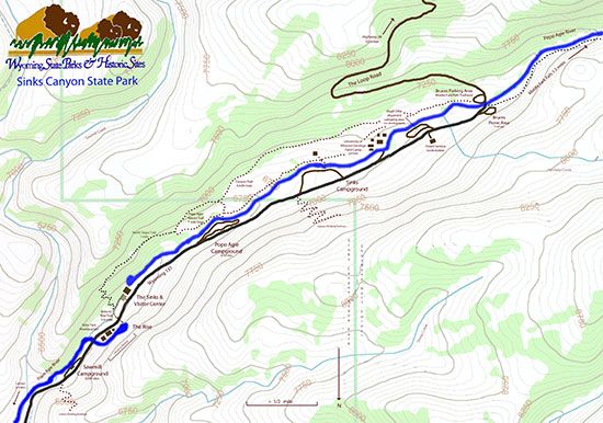
Click the map to download a larger printable version of this map.
Lower Climbing Buttress
Length: approx. 1/2 mile
Difficulty: Moderate
This trail starts across from Sawmill Campground and climbs to the top of the Tensleep sandstone cliffs on the south facing slope. Short and steep.
The Sinks to Rise Trail (also known as Junior Ranger Trail)
Length: 1/2 mile
Difficulty: Easy
Map Link (Sinks To Rise)
A 1/2 mile trail between the Sinks and the Rise. This is a paved, fully ADA accessible, trail that connects the Sinks and the Rise. The trail crosses sagebrush meadows, through Riparian zones, and along the overflow channel with fantastic views of the soaring sandstone cliffs. Interpretive signs along the trial explain the geology, history and ecology of the area. A short, unpaved, loop trail branches off and goes along the overflow channel to signs that talk about the high spring water in the usually dry channel.
The North Slope Trail
Length: 1 mile
Difficulty: Moderate
Map Link
The North Slope Trail is the newest hiking trail in the canyon, and connects the Popo Agie Nature Trail to the Sinks to Rise Trail. Now hikers can hike from the Rise all the way to the Falls on beautiful trails if they wish. To access the trail on the lower end start at the Rise and follow the paved path called the Sinks to Rise Trail towards the Sinks. Across Highway 131 and about 100 yards down the trail a dirt trail cuts off towards the overflow channel (there is a sign for the North Slope trail here). Cross the overflow channel (a rocky dry streambed which cannot safely be crossed during spring runoff when it is full of water), then climb a series of steep switchbacks until you are in the heavy timber of the north facing slope. From here the trail follows the contours of the slope up canyon offering beautiful views down to the Lander Valley and up to the Wind River Mountains. The trail is rocky and steep in places. After a mile it drops into a meadow and joins the Popo Agie Nature Trail.
The Popo Agie Nature Trail
Length: 1 mile
Difficulty: Easy
Map Link
This trail is a lovely one mile loop that highlights the different habitats in the canyon. It winds through sagebrush meadows, conifer forests, aspen groves and riparian areas along the river.
Interpretive signs along the trail talk about the flora, fauna and geology.
The trail starts at the suspension bridge at the upper end of the Popo Agie Campground, climbs a short hill and winds back to the bridge. The hike is easy, but wear sturdy shoes since the trail is rocky in places.
Unnamed North Climbing Trail
Length: approx. 1 mile (?)
Difficulty: Moderate
This trail branches off from the Popo Agie Nature Trail (about halfway along the trail) and climbs to the Madison Limestone on the north facing slope.
The Canyon Trail
Length: 4 miles
Difficulty: Moderate
Map Link
This trail is a four mile loop that begins at the suspension bridge in Popo Agie Campground, follows the natural trail for a few hundred yards, then cuts up canyon. The trail goes to Bruces Picnic Area and returns along the river to the suspension bridge.
This trail goes through sagebrush meadows, a large section of the pine forest, past and over glacial moraines, along the river and through aspen groves.
It gives a great overview of the canyon walls and habitats.
Upper Climbing Buttress
Length: approx. 1 mile (?)
Difficulty: Moderate
This trail starts just past the state park boundary at the upper end of the canyon and switchbacks up the south facing slope to a popular climbing area called "killer cave."
Trails to climbing walls (general information):
In the canyon are several short, steep trails lead to climbing walls that can be used by anyone. The trails end at the climbing areas, but hikers can use them to access the base of the cliffs and then bushwhack from there. One trail (Lower Climbing Buttress) starts across from Sawmill Campground and climbs to the top of the Tensleep sandstone cliffs on the south facing slope. Another (Unnamed North Climbing Trail) branches off from the Popo Agie Nature Trail (about halfway along the trail) and climbs to the Madison Limestone on the north facing slope. A third (Upper Climbing Buttress) climbing trail starts just past the state park boundary at the upper end of the canyon and switchbacks up the south facing slope to a popular climbing area called "killer cave." Although these trails are short, they are very steep.