Geology from Precambrian Granite to the Laramide Uplift
Wyoming has some of the oldest, most complex, and most easily viewed geology in North America. Much of that geology is visible in and around Sinks Canyon, which cuts into the southeastern slope of the Wind River Mountains.
The geologic history is critical to the understanding of the canyon, because the ecology was created by the geology and is still directly affected by it. Years could be spent studying the geology of the area, but a quick overview will orient you to the canyon’s place in the geologic history.
For many millions of years Wyoming was a flat plain under prehistoric oceans that came and went. During each period of being under water, sediment was deposited. The sediment was from volcanic ash falling over the water, dust and sand being blown across by winds, erosion from nearby landmasses flowing into the sea. Only a tiny fraction was deposited in any given year, but over millions of years thick beds of soil were deposited, each building up and compressing deeper layers. The pressure from the thousands of feet of deposits above as well as heat from the earth’s core worked to turn the deposits into various sandstones, limestones and other rock formations.
These thick layers of sedimentary rock covered the much older bedrock made up mostly of Precambrian granite formed 4 billion years ago when the planet was first created. As these sedimentary layers were being deposited, the plates that make up the earth’s surface were slowly moving. Wyoming was once part of a landmass that was in the tropics for much of its geologic history. Fossils of tropical plants and animals are found in many of the layers of rock in the state. Over millions of years the plates moved to roughly form the continents as we know them today. About 135 million years ago a major geologic event occurred; the Laramide Uplift. This uplift created the Rocky Mountains when a great mass of hot rock from the Earth’s core rose towards the surface, lifting and stretching the continental crust.
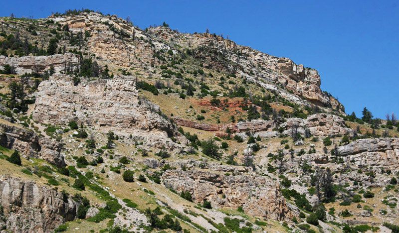
This uplift forced the deeply buried bedrock to punch up through the layers of sedimentary rock. As the bedrock pushed up it tilted the layers of sedimentary rock. As you travel through the canyon you can easily see the layers tilting downward from the high peaks towards the valley. The Wind River Range is one of the greatest localized vertical displacements of crustal rock known anywhere in the world. Even as the uplift occurred, erosion, volcanic deposits, and earthquakes kept the mountains largely buried in debris. Entire formations often disappeared as they eroded away. Canyons such as this one and the jagged granite peaks along the continental divide didn’t yet exist. The pictures below show the sedimentary layers visible in the lower half of the canyon.
-
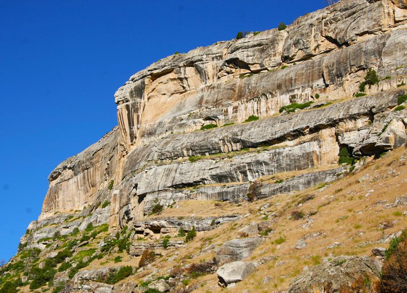
The uppermost cliffs in the lower part of the canyon are Tensleep Sandstone. This formation is from the Pennsylvanian Age (280-310 million years ago). Tensleep Sandstone is a porous quartz sandstone which holds oil in the space between the grains of sand. The red and black streaking on the cliffs are oxides of iron and manganese and are called “desert varnish.”
-
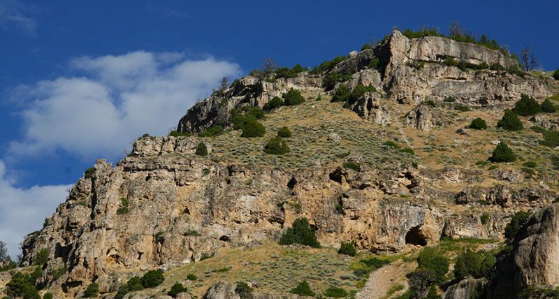
This jagged-looking formation is called Madison Limestone (from the Mississippian period (325-345 million years ago). Limestone is easily eroded by a weak, naturally forming acid created by a combination of water and carbon dioxide in the atmosphere. This erosion gives the formation the many pockets, sink holes, outcrops and caves and is called “Karst topography.”” The Popo Agie River running over granite boulders (deposited by glacial activity and the river) into the Madison Limestone formation. The Madison is hundreds of feet thick.
-
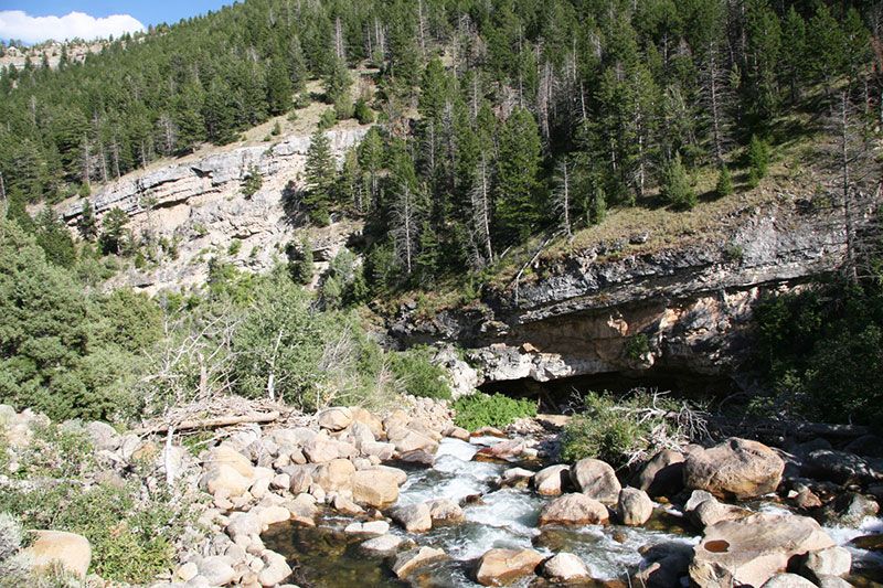
The Popo Agie River flowing into the sinks cave in the Madison Limestone. The sinks are likely thousands of years old. Geologists think the glaciers during the Ice Ages exposed the limestone and the water from the melting ice flowed into the cracks in the Madison formation eroding out passages and channels underground.
-
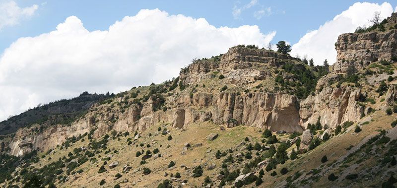
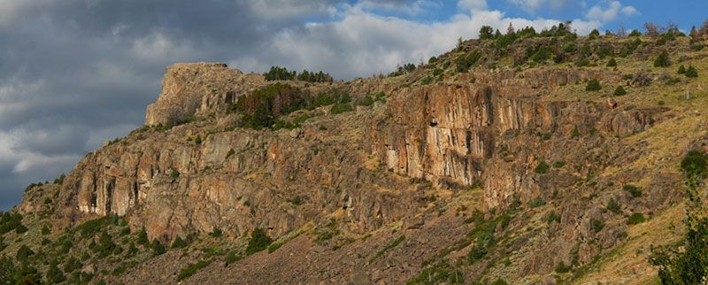
Big Horn dolomite (from the Ordivician period 425 to 500 million years ago) is visible at the state park boundary up canyon. Dolomite is similar to limestone, but is harder and resistant to erosion, giving it massive “clean looking” faces when exposed. It contains fossils such as corals, brachiopods and trilobites. These rock faces are popular with rock climbers because they aren’t as soft and crumbly as the Madison and Tensleep formations.
-
The Amsden Formation (from the Pennsylvanian-Mississippian period 325 million years) is a thin layer of soft red sandstone that has mostly eroded away in the canyon. Thin bands of it can sometimes be seen between the Tensleep and Madison formations.
-
The Precambrian Granite at the upper end of the canyon. This ancient "basement rock" was created billions of years ago when the earth first formed. It was pushed up through the sedimentary rock layers when the Wind River Range was created by plate tectonics which pushed the deeply buried granite up to create the mountains. The granite was carved and polished by recent ice ages. On top the the cliffs can be seen glacial erratics, glacial scarring and polish.